
Make a donation
Gear up for your next adventure:
As an Amazon Associate, this site earns from qualifying purchases at no extra cost to you.
Gundelsheim topographic map
Click on the map to display elevation.
Make a donation
Gear up for your next adventure:
As an Amazon Associate, this site earns from qualifying purchases at no extra cost to you.
About this map
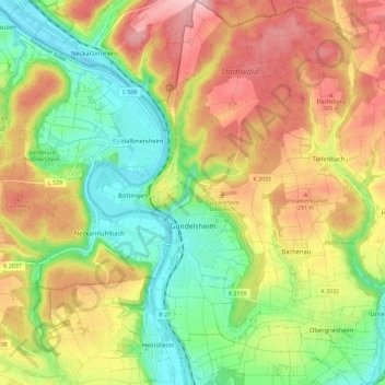
Name: Gundelsheim topographic map, elevation, terrain.
Average elevation: 758 ft
Minimum elevation: 446 ft
Maximum elevation: 1,125 ft
Make a donation
Gear up for your next adventure:
As an Amazon Associate, this site earns from qualifying purchases at no extra cost to you.
Other topographic maps
Click on a map to view its topography, its elevation and its terrain.
Schweizerhof
Deutschland > Baden-Württemberg > Landkreis Heilbronn > Wüstenrot
Average elevation: 1,365 ft
Neudeck
Deutschland > Baden-Württemberg > Landkreis Heilbronn > Langenbrettach > Langenbeutingen
Average elevation: 751 ft
Meimsheim
Deutschland > Baden-Württemberg > Landkreis Heilbronn > Brackenheim
Im 12. und 13. Jahrhundert existierte mit den Herren von Meimsheim ein Ortsadel, der in Meimsheim eine Burg bzw. ein Schloss bewohnt haben soll. Die auf der südlich des Ortes gelegenen Rosenhöhe gefundenen Mauerreste (Gewann Burgstättle) sollen die Fundamente dieses Herrschaftssitzes sein. Um 1345 traten…
Average elevation: 699 ft
Make a donation
Gear up for your next adventure:
As an Amazon Associate, this site earns from qualifying purchases at no extra cost to you.
Landturm
Deutschland > Baden-Württemberg > Landkreis Heilbronn > Lauffen am Neckar
Average elevation: 764 ft
Untergriesheim
Deutschland > Baden-Württemberg > Landkreis Heilbronn > Bad Friedrichshall > Untergriesheim
Average elevation: 676 ft