
Make a donation
Gear up for your next adventure:
As an Amazon Associate, this site earns from qualifying purchases at no extra cost to you.
Vilaseca topographic map
Click on the map to display elevation.
Make a donation
Gear up for your next adventure:
As an Amazon Associate, this site earns from qualifying purchases at no extra cost to you.
About this map
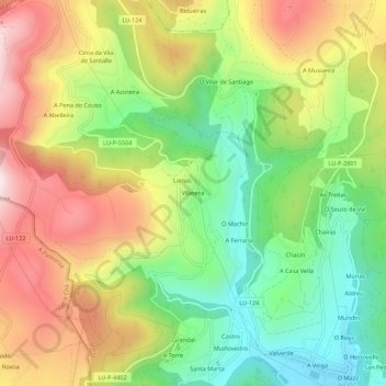
Name: Vilaseca topographic map, elevation, terrain.
Average elevation: 1,401 ft
Minimum elevation: 554 ft
Maximum elevation: 2,470 ft
Make a donation
Gear up for your next adventure:
As an Amazon Associate, this site earns from qualifying purchases at no extra cost to you.
Other topographic maps
Click on a map to view its topography, its elevation and its terrain.
Make a donation
Gear up for your next adventure:
As an Amazon Associate, this site earns from qualifying purchases at no extra cost to you.
Pol
Las mayores altitudes están hacia el este (Pena Grande, 935m, "Montes da Ferradura", 809 m y Penedo do Pao, 827 m). En los límites con Castro de Rey la altitud apenas supera los 400 m y las Colinas intermedias no superan los 650 m. De ellos parten numerosos arroyos y ríos.
Average elevation: 1,932 ft
Make a donation
Gear up for your next adventure:
As an Amazon Associate, this site earns from qualifying purchases at no extra cost to you.