
Olmos Basin Park topographic map
Interactive map
Click on the map to display elevation.
About this map
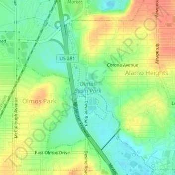
Name: Olmos Basin Park topographic map, elevation, terrain.
Average elevation: 751 ft
Minimum elevation: 679 ft
Maximum elevation: 833 ft
Other topographic maps
Click on a map to view its topography, its elevation and its terrain.
San Pedro Springs Park
United States > Texas > Bexar County > San Antonio
San Pedro Springs Park, 2200, San Antonio, Bexar County, Texas, 78212, United States
Average elevation: 702 ft
San Antonio
United States > Texas > Bexar County > San Antonio
San Antonio, Bexar County, Texas, 78205, United States
Average elevation: 715 ft
River Walk
United States > Texas > Bexar County > San Antonio
River Walk, Downtown, San Antonio, Bexar County, Texas, United States
Average elevation: 666 ft
Government Canyon State Natural Area
United States > Texas > Bexar County > San Antonio
Government Canyon State Natural Area, 12861, Galm Road, San Antonio, Bexar County, Texas, 78254, United States
Average elevation: 1,171 ft
Tom Slick Park
United States > Texas > Bexar County > San Antonio
Tom Slick Park, San Antonio, Bexar County, Texas, United States
Average elevation: 751 ft
Eisenhower Park
United States > Texas > Bexar County > San Antonio
Eisenhower Park, San Antonio, Bexar County, Texas, 78257, United States
Average elevation: 1,132 ft
Leon Creek
United States > Texas > Bexar County > San Antonio
Leon Creek, Leon Springs, San Antonio, Bexar County, Texas, 78257, United States
Average elevation: 1,184 ft
Travis Park
United States > Texas > Bexar County > San Antonio
Travis Park, Downtown, San Antonio, Bexar County, Texas, United States
Average elevation: 669 ft
Hardberger Park
United States > Texas > Bexar County > San Antonio
Hardberger Park, San Antonio, Bexar County, Texas, 78216, United States
Average elevation: 889 ft
Farias Park
United States > Texas > Bexar County > San Antonio
Farias Park, San Antonio, Bexar County, Texas, 78207, United States
Average elevation: 676 ft