
Make a donation
Gear up for your next adventure:
As an Amazon Associate, this site earns from qualifying purchases at no extra cost to you.
Sint-Kruis topographic map
Click on the map to display elevation.
Make a donation
Gear up for your next adventure:
As an Amazon Associate, this site earns from qualifying purchases at no extra cost to you.
Sint-Kruis
Sint-Kruis ligt aan de noordrand van Zandig Vlaanderen. De bosrijke omgeving vindt men vooral terug in landgoederen en villawijken. De Schobbejakshoogte, als onderdeel van het domein Ryckevelde, is een natuurgebied van 6 ha in het zuidoosten van Sint-Kruis, nabij de grens met de aanpalende Brugse deelgemeente Assebroek. Voorts is Sint-Kruis sterk verstedelijkt.
Make a donation
Gear up for your next adventure:
As an Amazon Associate, this site earns from qualifying purchases at no extra cost to you.
About this map
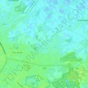
Name: Sint-Kruis topographic map, elevation, terrain.
Location: Sint-Kruis, Brugge, West-Vlaanderen, België (51.19709 3.23390 51.24032 3.30990)
Average elevation: 13 ft
Minimum elevation: -7 ft
Maximum elevation: 30 ft
Make a donation
Gear up for your next adventure:
As an Amazon Associate, this site earns from qualifying purchases at no extra cost to you.
Other topographic maps
Click on a map to view its topography, its elevation and its terrain.
Make a donation
Gear up for your next adventure:
As an Amazon Associate, this site earns from qualifying purchases at no extra cost to you.