Geolocate

Gholson topographic map

Click on the map to display elevation.

About this map

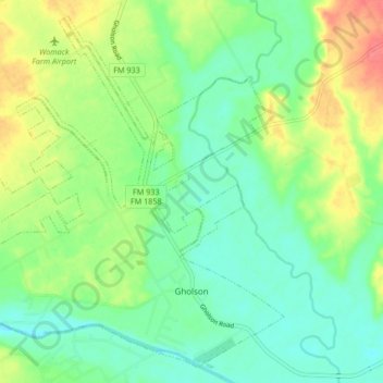
Name: Gholson topographic map, elevation, terrain.

Location: Gholson, McLennan County, Texas, United States (31.68681 -97.27967 31.75223 -97.19619)

Average elevation: 463 ft

Minimum elevation: 390 ft

Maximum elevation: 591 ft

McLennan County trails, hiking, mountain biking, running and outdoor activities

Other topographic maps

Click on a map to view its topography, its elevation and its terrain.

Wiggins

United States > Texas > McLennan County

Average elevation: 564 ft

Waco

United States > Texas > McLennan County > Waco

Average elevation: 492 ft

McGregor

United States > Texas > McLennan County > McGregor > McGregor

Average elevation: 715 ft

Tehuacana Creek

United States > Texas > McLennan County > Neale

Average elevation: 394 ft

Speegleville

United States > Texas > McLennan County > Waco

Average elevation: 495 ft

Bruceville-Eddy

United States > Texas > McLennan County

Average elevation: 650 ft

Eddy

United States > Texas > McLennan County > Bruceville-Eddy

Average elevation: 692 ft

Bosqueville

United States > Texas > McLennan County > Waco > Bosqueville

Average elevation: 443 ft

Gear up for your next adventure:

🎒Trekking Poles - Sturdy poles for balance and stability on rough terrain
🚗GPS Dash Cams - Record your scenic drives through mountain passes and canyons
🔦LED Headlamp - Bright and durable LED headlamp for night navigation
🌲Outdoor Survival Books - Best books on survival skills
🚁Photography Drones - Capture stunning aerial views of landforms and topography

As an Amazon Associate, this site earns from qualifying purchases at no extra cost to you.