
Make a donation
Gear up for your next adventure:
As an Amazon Associate, this site earns from qualifying purchases at no extra cost to you.
Baunei topographic map
Click on the map to display elevation.
Make a donation
Gear up for your next adventure:
As an Amazon Associate, this site earns from qualifying purchases at no extra cost to you.
Baunei
Grazie all'esposizione e all'altitudine di 480 m, Baunei si sporge sull'Ogliastra contemplando un anfiteatro di colline e montagne (fra le quali la punta S'Abbadorgiu) su cui si stagliano le vette più alte del Gennargentu.
Make a donation
Gear up for your next adventure:
As an Amazon Associate, this site earns from qualifying purchases at no extra cost to you.
About this map
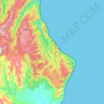
Name: Baunei topographic map, elevation, terrain.
Location: Baunei, Ogliastra, Sardegna, 08040, Italia (39.98657 9.54706 40.22495 9.73557)
Average elevation: 863 ft
Minimum elevation: -3 ft
Maximum elevation: 3,671 ft
Make a donation
Gear up for your next adventure:
As an Amazon Associate, this site earns from qualifying purchases at no extra cost to you.
Other topographic maps
Click on a map to view its topography, its elevation and its terrain.