Geolocate

Gordon topographic map

Click on the map to display elevation.

About this map

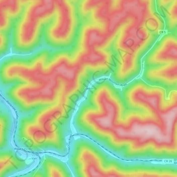
Name: Gordon topographic map, elevation, terrain.

Location: Gordon, Boone County, West Virginia, 25092, United States (37.96705 -81.71539 38.00705 -81.67539)

Average elevation: 1,312 ft

Minimum elevation: 794 ft

Maximum elevation: 1,804 ft

Boone County trails, hiking, mountain biking, running and outdoor activities

Other topographic maps

Click on a map to view its topography, its elevation and its terrain.

Whitesville

United States > West Virginia > Boone County

Average elevation: 1,352 ft

Madison

United States > West Virginia > Boone County

Average elevation: 1,066 ft

Danville

United States > West Virginia > Boone County

Average elevation: 919 ft

Sylvester

United States > West Virginia > Boone County

Average elevation: 1,266 ft

Gear up for your next adventure:

🪑Portable Camp Table - Compact table for campsite meals
🪶Camp Gear Gift Set - Perfect gift bundle for outdoor fans
🔋Solar Power Banks - Keep your GPS and phone charged in remote wilderness areas
🪶Wildlife Field Guides - Learn animal tracking and species ID
🧯Portable Fire Pit - Compact fire pit for camping spots

As an Amazon Associate, this site earns from qualifying purchases at no extra cost to you.