
Make a donation
Gear up for your next adventure:
As an Amazon Associate, this site earns from qualifying purchases at no extra cost to you.
Getafe topographic map
Click on the map to display elevation.
Make a donation
Gear up for your next adventure:
As an Amazon Associate, this site earns from qualifying purchases at no extra cost to you.
Getafe
Getafe is located in the southern zone of the autonomous community of Madrid, Spain, in southwestern Europe. It is physically located in the centre of the Iberian Peninsula, north of the Southern Submeseta (part of the Meseta Central), in the Manzanares River basin. Its elevation is 610 – 640 meters above sea level (2000–2100 feet). Its coordinates are 40° 18' N 3° 43' W. The municipal district is 78.74 km2, with a perimeter of 46.5 km. The easternmost part of the municipal district is located within the Parque Regional del Sureste, a protected forest region.
Make a donation
Gear up for your next adventure:
As an Amazon Associate, this site earns from qualifying purchases at no extra cost to you.
About this map
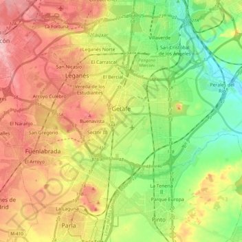
Name: Getafe topographic map, elevation, terrain.
Location: Getafe, Community of Madrid, Spain (40.26636 -3.76174 40.33470 -3.57006)
Average elevation: 2,073 ft
Minimum elevation: 1,804 ft
Maximum elevation: 2,382 ft
Make a donation
Gear up for your next adventure:
As an Amazon Associate, this site earns from qualifying purchases at no extra cost to you.
Other topographic maps
Click on a map to view its topography, its elevation and its terrain.
Make a donation
Gear up for your next adventure:
As an Amazon Associate, this site earns from qualifying purchases at no extra cost to you.
Alcorcón
Spain > Community of Madrid > Área metropolitana de Madrid y Corredor del Henares > Alcorcón
Average elevation: 2,119 ft
La Castellana y El Pilar
Spain > Community of Madrid > Sierra Oeste > Cadalso de los Vidrios
Average elevation: 2,585 ft