Geolocate

Wick topographic map

Click on the map to display elevation.

About this map

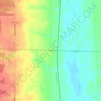
Name: Wick topographic map, elevation, terrain.

Location: Wick, Wayne Township, Ashtabula County, Ohio, United States (41.51422 -80.66730 41.55422 -80.62730)

Average elevation: 1,004 ft

Minimum elevation: 912 ft

Maximum elevation: 1,125 ft

Ashtabula County trails, hiking, mountain biking, running and outdoor activities

Other topographic maps

Click on a map to view its topography, its elevation and its terrain.

Ashtabula

United States > Ohio > Ashtabula County

Average elevation: 656 ft

Roaming Shores

United States > Ohio > Ashtabula County

Average elevation: 883 ft

Rock Creek

United States > Ohio > Ashtabula County

Average elevation: 814 ft

Edgewood

United States > Ohio > Ashtabula County

Average elevation: 702 ft

North Kingsville

United States > Ohio > Ashtabula County

Average elevation: 650 ft

New Lyme Township

United States > Ohio > Ashtabula County

Average elevation: 994 ft

Conneaut

United States > Ohio > Ashtabula County

Average elevation: 696 ft

Jefferson

United States > Ohio > Ashtabula County

Average elevation: 935 ft

Geneva

United States > Ohio > Ashtabula County

Average elevation: 591 ft

Gear up for your next adventure:

🧷Carabiner Set - Durable clips for gear attachment
🔭Stargazing Telescopes - Perfect for camping in low-light pollution areas shown on maps
🥾Women's Hiking Boots - Top-rated trail boots with ankle support and superior grip
❄️Traction Cleats - Prevent slips on icy trails during winter hikes
👖Convertible Hiking Pants - Versatile zip-off pants for changing altitudes and temperatures

As an Amazon Associate, this site earns from qualifying purchases at no extra cost to you.