
Menfi topographic map
Interactive map
Click on the map to display elevation.
About this map
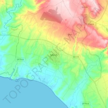
Name: Menfi topographic map, elevation, terrain.
Location: Menfi, Agrigent, Sizilien, 92013, Italien (37.53858 12.88696 37.67703 13.04805)
Average elevation: 446 ft
Minimum elevation: 0 ft
Maximum elevation: 1,365 ft
Other topographic maps
Click on a map to view its topography, its elevation and its terrain.
Santa Margherita di Belice
Santa Margherita di Belice, Agrigent, Sizilien, 92018, Italien
Average elevation: 902 ft
Montallegro
Montallegro, Agrigent, Sizilien, 92010, Italien
Average elevation: 394 ft