Geolocate

Wisconsin River topographic map

Click on the map to display elevation.

About this map

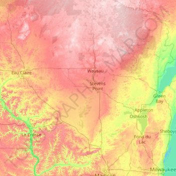
Name: Wisconsin River topographic map, elevation, terrain.

Location: Wisconsin River, Wood County, Wisconsin, 54519, USA (42.98836 -91.15680 46.15201 -89.04941)

Average elevation: 1,093 ft

Minimum elevation: 564 ft

Maximum elevation: 1,890 ft

Other topographic maps

Click on a map to view its topography, its elevation and its terrain.

Milwaukee River

USA > Wisconsin > Glendale

Average elevation: 643 ft

Gear up for your next adventure:

🦟Ultrasonic Repellers - Create a bug-free zone at your camp or rest stop
🎒Trail Energy Bars - High‑calorie bars for hiking energy
🪶Fire Starter Kit - Reliable fire starter for survival and camping
🧦Hiking Socks - Comfortable socks to prevent blisters on long hikes
🕶️GPS Smartphone Mount - Secure mount for phone navigation

As an Amazon Associate, this site earns from qualifying purchases at no extra cost to you.