
Thank you for supporting this site ❤️
Make a donation
Make a donation
Gear up for your next adventure:
As an Amazon Associate, this site earns from qualifying purchases at no extra cost to you.
Shiwikis topographic map
Click on the map to display elevation.
Thank you for supporting this site ❤️
Make a donation
Make a donation
Gear up for your next adventure:
As an Amazon Associate, this site earns from qualifying purchases at no extra cost to you.
About this map
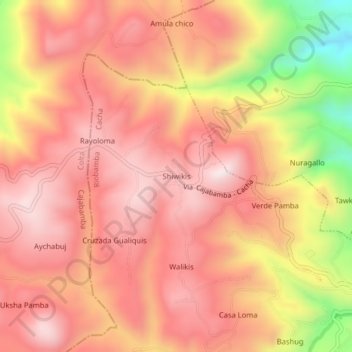
Name: Shiwikis topographic map, elevation, terrain.
Location: Shiwikis, Cacha, Riobamba, Chimborazo, 060114, Ecuador (-1.71264 -78.74210 -1.67264 -78.70210)
Average elevation: 10,892 ft
Minimum elevation: 9,465 ft
Maximum elevation: 11,591 ft
Thank you for supporting this site ❤️
Make a donation
Make a donation
Gear up for your next adventure:
As an Amazon Associate, this site earns from qualifying purchases at no extra cost to you.