
Thorpe topographic map
Click on the map to display elevation.
About this map
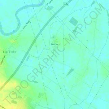
Name: Thorpe topographic map, elevation, terrain.
Average elevation: 52 ft
Minimum elevation: 33 ft
Maximum elevation: 102 ft
Other topographic maps
Click on a map to view its topography, its elevation and its terrain.
Vicar Water Country Park
United Kingdom > England > Nottinghamshire > Newark and Sherwood > Clipstone
Average elevation: 318 ft
New Ollerton
United Kingdom > England > Nottinghamshire > Newark and Sherwood
Average elevation: 171 ft
Newark on Trent
United Kingdom > England > Nottinghamshire > Newark and Sherwood
Average elevation: 59 ft
Sherwood Forest NNR
United Kingdom > England > Nottinghamshire > Newark and Sherwood > Ollerton
Average elevation: 233 ft
Danethorpe Hill
United Kingdom > England > Nottinghamshire > Newark and Sherwood
Average elevation: 72 ft
Farndon
United Kingdom > England > Nottinghamshire > Newark and Sherwood > Farndon
Average elevation: 46 ft
Blidworth Bottoms
United Kingdom > England > Nottinghamshire > Newark and Sherwood > Blidworth CP
Average elevation: 351 ft
Goverton
United Kingdom > England > Nottinghamshire > Newark and Sherwood > Bleasby
Average elevation: 112 ft
Spalford Warren
United Kingdom > England > Nottinghamshire > Newark and Sherwood > Spalford
Average elevation: 23 ft
Kings Clipstone
United Kingdom > England > Nottinghamshire > Newark and Sherwood
Average elevation: 266 ft
Sherwood Forest NNR
United Kingdom > England > Nottinghamshire > Newark and Sherwood > Ollerton
Average elevation: 233 ft