
Derby topographic map
Click on the map to display elevation.
Derby
According to the United States Census Bureau, the town has a total area of 5.4 square miles (8.7 km2), of which, 5.0 square miles (13 km2) is land and 0.4 square miles (1.0 km2) (7.41%) is water. The city is home to the 417 acres (0.652 sq mi) Osbornedale State Park. Derby is divided into two main sections by the Naugatuck River: East Derby and Derby Center (Birmingham). The center of Derby is approximately 66 miles (106 km) from New York City. The lowest elevation is 3 ft (1m) and the highest elevation is 466 ft (142m) above sea level.
About this map
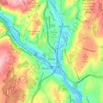
Name: Derby topographic map, elevation, terrain.
Average elevation: 256 ft
Minimum elevation: -16 ft
Maximum elevation: 594 ft
Naugatuck Valley Planning Region trails, hiking, mountain biking, running and outdoor activities
Other topographic maps
Click on a map to view its topography, its elevation and its terrain.
Huntington
United States > Connecticut > Naugatuck Valley Planning Region > Shelton
Average elevation: 364 ft
Minortown
United States > Connecticut > Naugatuck Valley Planning Region > Woodbury
Average elevation: 554 ft
Millville
United States > Connecticut > Naugatuck Valley Planning Region > Naugatuck > Union City
Average elevation: 433 ft
White Hills
United States > Connecticut > Naugatuck Valley Planning Region > Shelton
Average elevation: 407 ft
East Derby
United States > Connecticut > Naugatuck Valley Planning Region > Derby
Average elevation: 197 ft
Mad River
United States > Connecticut > Naugatuck Valley Planning Region > Waterbury > Fair Lawn
Average elevation: 440 ft
Minortown
United States > Connecticut > Naugatuck Valley Planning Region > Woodbury
Average elevation: 554 ft
Bunker Hill
United States > Connecticut > Naugatuck Valley Planning Region > Waterbury
Average elevation: 459 ft
Traditions
United States > Connecticut > Naugatuck Valley Planning Region > Southbury > South Britain
Average elevation: 367 ft
Fox Hollow
United States > Connecticut > Naugatuck Valley Planning Region > Cheshire
Average elevation: 210 ft
Union City
United States > Connecticut > Naugatuck Valley Planning Region > Naugatuck
Average elevation: 407 ft
Town Plot Hill
United States > Connecticut > Naugatuck Valley Planning Region > Waterbury
Average elevation: 417 ft
Bunker Hill
United States > Connecticut > Naugatuck Valley Planning Region > Waterbury
Average elevation: 459 ft
Millville
United States > Connecticut > Naugatuck Valley Planning Region > Naugatuck
Average elevation: 433 ft
Bunker Hill
United States > Connecticut > Naugatuck Valley Planning Region > Waterbury
Average elevation: 459 ft
Westview Heights
United States > Connecticut > Naugatuck Valley Planning Region > Middlebury
Average elevation: 522 ft
Warsaw Park
United States > Connecticut > Naugatuck Valley Planning Region > Ansonia
Average elevation: 351 ft
Allentown
United States > Connecticut > Naugatuck Valley Planning Region > Plymouth
Average elevation: 801 ft
Cedar Land
United States > Connecticut > Naugatuck Valley Planning Region > Southbury
Average elevation: 338 ft
Gulls Hollow
United States > Connecticut > Naugatuck Valley Planning Region > Bethlehem
Average elevation: 797 ft