
Make a donation
Gear up for your next adventure:
As an Amazon Associate, this site earns from qualifying purchases at no extra cost to you.
Dortches topographic map
Click on the map to display elevation.
Make a donation
Gear up for your next adventure:
As an Amazon Associate, this site earns from qualifying purchases at no extra cost to you.
About this map
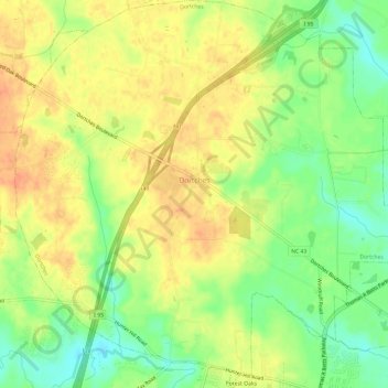
Name: Dortches topographic map, elevation, terrain.
Location: Dortches, Nash County, North Carolina, United States (35.98541 -77.88516 36.03368 -77.82661)
Average elevation: 167 ft
Minimum elevation: 89 ft
Maximum elevation: 226 ft
Nash County trails, hiking, mountain biking, running and outdoor activities
Make a donation
Gear up for your next adventure:
As an Amazon Associate, this site earns from qualifying purchases at no extra cost to you.
Other topographic maps
Click on a map to view its topography, its elevation and its terrain.
Rocky Mount Millpond Dam
United States > North Carolina > Nash County > Rocky Mount
Average elevation: 105 ft
Little Easonburg
United States > North Carolina > Nash County > Rocky Mount > Little Easonburg
Average elevation: 157 ft
Make a donation
Gear up for your next adventure:
As an Amazon Associate, this site earns from qualifying purchases at no extra cost to you.