
Make a donation
Gear up for your next adventure:
As an Amazon Associate, this site earns from qualifying purchases at no extra cost to you.
Forestdale topographic map
Click on the map to display elevation.
Make a donation
Gear up for your next adventure:
As an Amazon Associate, this site earns from qualifying purchases at no extra cost to you.
About this map
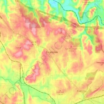
Name: Forestdale topographic map, elevation, terrain.
Location: Forestdale, Jefferson County, Alabama, 35214, United States (33.53011 -86.93638 33.61011 -86.85638)
Average elevation: 591 ft
Minimum elevation: 354 ft
Maximum elevation: 755 ft
Make a donation
Gear up for your next adventure:
As an Amazon Associate, this site earns from qualifying purchases at no extra cost to you.
Other topographic maps
Click on a map to view its topography, its elevation and its terrain.
Valley Creek
United States > Alabama > Jefferson County > Birmingham > Graymont
Average elevation: 594 ft
Make a donation
Gear up for your next adventure:
As an Amazon Associate, this site earns from qualifying purchases at no extra cost to you.