
Make a donation
Gear up for your next adventure:
As an Amazon Associate, this site earns from qualifying purchases at no extra cost to you.
Carlisle topographic map
Click on the map to display elevation.
Make a donation
Gear up for your next adventure:
As an Amazon Associate, this site earns from qualifying purchases at no extra cost to you.
Carlisle
Carlisle is located slightly northeast of the center of Cumberland County at 40°12′9″N 77°11′42″W / 40.20250°N 77.19500°W / 40.20250; -77.19500 (40.202553, −77.195016) at an elevation of 479 feet (146 m).[24][25] The borough lies in the Cumberland Valley, a section of the Great Appalachian Valley, to the south of Conodoguinet Creek, a tributary of the Susquehanna River. Letort Spring Run, a tributary of Conodoguinet Creek, runs north through the eastern part of the borough.
Make a donation
Gear up for your next adventure:
As an Amazon Associate, this site earns from qualifying purchases at no extra cost to you.
About this map
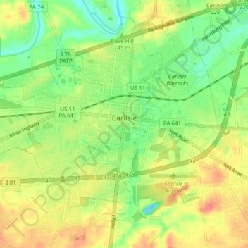
Name: Carlisle topographic map, elevation, terrain.
Average elevation: 486 ft
Minimum elevation: 400 ft
Maximum elevation: 577 ft
Cumberland County trails, hiking, mountain biking, running and outdoor activities
Make a donation
Gear up for your next adventure:
As an Amazon Associate, this site earns from qualifying purchases at no extra cost to you.
Other topographic maps
Click on a map to view its topography, its elevation and its terrain.
Carlisle Springs
United States > Pennsylvania > Cumberland County > Middlesex Township
Average elevation: 597 ft
Pine Grove Furnace
United States > Pennsylvania > Cumberland County > Cooke Township
Average elevation: 1,089 ft
Mount Zion
United States > Pennsylvania > Cumberland County > South Middleton Township
Average elevation: 587 ft
Carlisle Springs
United States > Pennsylvania > Cumberland County > Middlesex Township
Average elevation: 597 ft
Make a donation
Gear up for your next adventure:
As an Amazon Associate, this site earns from qualifying purchases at no extra cost to you.
Chestnut Crossroads
United States > Pennsylvania > Cumberland County > Southampton Township
Average elevation: 840 ft
Green Spring
United States > Pennsylvania > Cumberland County > North Newton Township
Average elevation: 571 ft
Treemont
United States > Pennsylvania > Cumberland County > East Pennsboro Township
Average elevation: 531 ft
Caprivi
United States > Pennsylvania > Cumberland County > North Middleton Township
Average elevation: 512 ft
Make a donation
Gear up for your next adventure:
As an Amazon Associate, this site earns from qualifying purchases at no extra cost to you.
Springville
United States > Pennsylvania > Cumberland County > South Middleton Township
Average elevation: 531 ft
Liebys Trailer Park
United States > Pennsylvania > Cumberland County > Liebys Trailer Park
Average elevation: 453 ft
Drexel Hills
United States > Pennsylvania > Cumberland County > New Cumberland
Average elevation: 364 ft