
Thank you for supporting this site ❤️
Make a donation
Make a donation
Gear up for your next adventure:
As an Amazon Associate, this site earns from qualifying purchases at no extra cost to you.
Treemont topographic map
Click on the map to display elevation.
Thank you for supporting this site ❤️
Make a donation
Make a donation
Gear up for your next adventure:
As an Amazon Associate, this site earns from qualifying purchases at no extra cost to you.
About this map
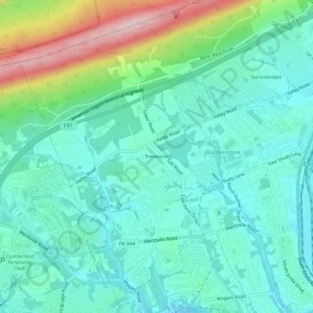
Name: Treemont topographic map, elevation, terrain.
Average elevation: 531 ft
Minimum elevation: 322 ft
Maximum elevation: 1,175 ft
Thank you for supporting this site ❤️
Make a donation
Make a donation
Gear up for your next adventure:
As an Amazon Associate, this site earns from qualifying purchases at no extra cost to you.
Other topographic maps
Click on a map to view its topography, its elevation and its terrain.
Enola
United States > Pennsylvania > Cumberland County > East Pennsboro Township > Enola
Average elevation: 390 ft
West Fairview
United States > Pennsylvania > Cumberland County > East Pennsboro Township > West Fairview
Average elevation: 344 ft