Geolocate

Lander topographic map

Click on the map to display elevation.

About this map

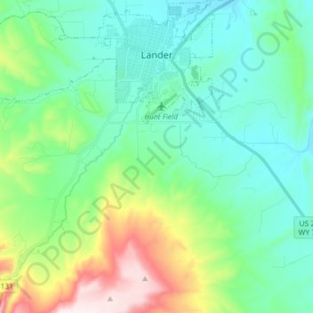
Name: Lander topographic map, elevation, terrain.

Location: Lander, Fremont County, Wyoming, 82520, United States (42.74570 -108.82125 42.85155 -108.68460)

Average elevation: 5,771 ft

Minimum elevation: 5,240 ft

Maximum elevation: 7,402 ft

Fremont County trails, hiking, mountain biking, running and outdoor activities

Other topographic maps

Click on a map to view its topography, its elevation and its terrain.

Wind River Range

United States > Wyoming > Fremont County

Average elevation: 12,159 ft

Miners Delight

United States > Wyoming > Fremont County

Average elevation: 8,186 ft

Gannett Peak

United States > Wyoming > Fremont County

Gannett Peak is the highest mountain peak in the U.S. state of Wyoming at 13,810 feet (4,210 m). It lies in the Wind River Range within the Bridger Wilderness of the Bridger-Teton National Forest. Straddling the Continental Divide along the boundary between Fremont and Sublette counties, it has the second…

Average elevation: 12,139 ft

Atlantic Peak

United States > Wyoming > Fremont County

Average elevation: 11,467 ft

Gannett Peak

United States > Wyoming > Fremont County

Gannett Peak is the highest mountain peak in the U.S. state of Wyoming at 13,810 feet (4,210 m). It lies in the Wind River Range within the Bridger Wilderness of the Bridger-Teton National Forest. Straddling the Continental Divide along the boundary between Fremont and Sublette counties, it has the second…

Average elevation: 12,139 ft

Canyon Lake

United States > Wyoming > Fremont County

Average elevation: 11,427 ft

Shale Mountain

United States > Wyoming > Fremont County

Average elevation: 12,021 ft

Pingora Peak

United States > Wyoming > Fremont County

Average elevation: 11,004 ft

Fremont Peak

United States > Wyoming > Fremont County

Average elevation: 12,149 ft

Wind River Range

United States > Wyoming > Fremont County

Average elevation: 12,159 ft

Wind River Range

United States > Wyoming > Fremont County

Average elevation: 12,159 ft

Pylon Peak

United States > Wyoming > Fremont County

Average elevation: 11,115 ft

Collins Place

United States > Wyoming > Fremont County

Average elevation: 7,041 ft

Chimney Rock

United States > Wyoming > Fremont County

Average elevation: 11,900 ft

Mount Burwell

United States > Wyoming > Fremont County

Average elevation: 11,112 ft

Gold Creek

United States > Wyoming > Fremont County

Average elevation: 8,074 ft

Mount Popo Agie

United States > Wyoming > Fremont County

Average elevation: 9,344 ft

Mount Warren

United States > Wyoming > Fremont County

Average elevation: 12,264 ft

Gear up for your next adventure:

🥾Women's Hiking Boots - Top-rated trail boots with ankle support and superior grip
🧦Merino Wool Socks - Moisture-wicking, blister-preventing socks for long treks
📖Nature Tracking Books - Learn to track wildlife and terrain
Camping Coffee Makers - Enjoy premium coffee at the summit or campsite
🔦Powerful Headlamps - Ultra-bright hands-free lighting for night navigation

As an Amazon Associate, this site earns from qualifying purchases at no extra cost to you.