Geolocate

Wind River Range topographic map

Click on the map to display elevation.

About this map

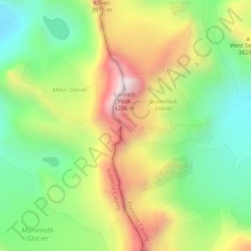
Name: Wind River Range topographic map, elevation, terrain.

Location: Wind River Range, Fremont County, Wyoming, United States (43.18031 -109.65386 43.18041 -109.65376)

Average elevation: 12,159 ft

Minimum elevation: 10,951 ft

Maximum elevation: 13,806 ft

Fremont County trails, hiking, mountain biking, running and outdoor activities

Other topographic maps

Click on a map to view its topography, its elevation and its terrain.

Lander

United States > Wyoming > Fremont County

Average elevation: 5,771 ft

Gannett Glacier

United States > Wyoming > Fremont County

Average elevation: 12,123 ft

Dubois

United States > Wyoming > Fremont County

Dubois is located at 43°32′9″N 109°38′9″W / 43.53583°N 109.63583°W / 43.53583; -109.63583 (43.535936, -109.635915) and an elevation of 2115 m (6940 ft). The Wind River runs through the town.

Average elevation: 7,110 ft

Hudson

United States > Wyoming > Fremont County

Average elevation: 5,121 ft

Shoshoni

United States > Wyoming > Fremont County

Average elevation: 4,839 ft

Canyon Lake

United States > Wyoming > Fremont County

Average elevation: 11,427 ft

Riverton

United States > Wyoming > Fremont County

Average elevation: 5,016 ft

Riverton

United States > Wyoming > Fremont County

Average elevation: 5,016 ft

Riverton

United States > Wyoming > Fremont County

Average elevation: 5,016 ft

Lander

United States > Wyoming > Fremont County

Average elevation: 5,771 ft

Riverton

United States > Wyoming > Fremont County

Average elevation: 5,016 ft

Atlantic City

United States > Wyoming > Fremont County

Average elevation: 7,917 ft

Pavillion

United States > Wyoming > Fremont County

Average elevation: 5,463 ft

Dubois

United States > Wyoming > Fremont County

Dubois is located at 43°32′9″N 109°38′9″W / 43.53583°N 109.63583°W / 43.53583; -109.63583 (43.535936, -109.635915) and an elevation of 2115 m (6940 ft). The Wind River runs through the town.

Average elevation: 7,110 ft

Gold Creek

United States > Wyoming > Fremont County

Average elevation: 8,074 ft

Gear up for your next adventure:

🌡️Portable Weather Meter - Track weather conditions on the trail
GPS Sports Watch - GPS watch for running, hiking and training
🗺️Topographic Maps - Detailed topo maps for hiking, exploring and outdoor navigation
🩳Quick‑Dry Hiking Shorts - Comfortable and quick‑dry shorts for summer hiking
🪶Camp Gear Gift Set - Perfect gift bundle for outdoor fans

As an Amazon Associate, this site earns from qualifying purchases at no extra cost to you.