
Thank you for supporting this site ❤️
Make a donation
Make a donation
Gear up for your next adventure:
As an Amazon Associate, this site earns from qualifying purchases at no extra cost to you.
Tarnol topographic map
Click on the map to display elevation.
Thank you for supporting this site ❤️
Make a donation
Make a donation
Gear up for your next adventure:
As an Amazon Associate, this site earns from qualifying purchases at no extra cost to you.
About this map
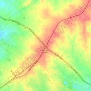
Name: Tarnol topographic map, elevation, terrain.
Location: Tarnol, Zone 1, Islamabad Capital Territory, Pakistan (33.63093 72.89041 33.67093 72.93041)
Average elevation: 1,916 ft
Minimum elevation: 1,788 ft
Maximum elevation: 2,008 ft
Thank you for supporting this site ❤️
Make a donation
Make a donation
Gear up for your next adventure:
As an Amazon Associate, this site earns from qualifying purchases at no extra cost to you.
Other topographic maps
Click on a map to view its topography, its elevation and its terrain.
Rawat Fort
Pakistan > Islamabad Capital Territory > Rawalpindi District > Channi Alam Sher > Dhoke Shah Alam Khan Number Dar
Average elevation: 1,844 ft