
Thank you for supporting this site ❤️
Make a donation
Make a donation
Gear up for your next adventure:
As an Amazon Associate, this site earns from qualifying purchases at no extra cost to you.
Bañón topographic map
Click on the map to display elevation.
Thank you for supporting this site ❤️
Make a donation
Make a donation
Gear up for your next adventure:
As an Amazon Associate, this site earns from qualifying purchases at no extra cost to you.
About this map
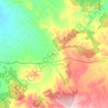
Name: Bañón topographic map, elevation, terrain.
Location: Bañón, Jiloca, Teruel, Aragón, Spanje (40.79396 -1.26316 40.88532 -1.16348)
Average elevation: 3,802 ft
Minimum elevation: 3,176 ft
Maximum elevation: 4,521 ft
Thank you for supporting this site ❤️
Make a donation
Make a donation
Gear up for your next adventure:
As an Amazon Associate, this site earns from qualifying purchases at no extra cost to you.