Geolocate

Geeveston topographic map

Click on the map to display elevation.

About this map

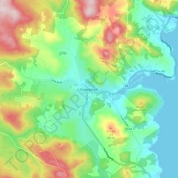
Name: Geeveston topographic map, elevation, terrain.

Location: Geeveston, Tasmania, 7116, Australia (-43.20379 146.88751 -43.12379 146.96751)

Average elevation: 436 ft

Minimum elevation: -13 ft

Maximum elevation: 1,276 ft

Gear up for your next adventure:

🧼Biodegradable Camping Soap - Eco‑friendly soap for outdoor hygiene
📱Solar Portable Charger - Solar power bank for charging devices off‑grid
📶Vehicle Signal Boosters - Improve reception in rural areas while driving to trailheads
🛰️Handheld GPS Units - Professional satellite navigators for precise backcountry mapping
🌎3D Topographic Globes - Raised relief globes for a tactile understanding of geography

As an Amazon Associate, this site earns from qualifying purchases at no extra cost to you.