
Make a donation
Gear up for your next adventure:
As an Amazon Associate, this site earns from qualifying purchases at no extra cost to you.
Harelbeke topographic map
Click on the map to display elevation.
Make a donation
Gear up for your next adventure:
As an Amazon Associate, this site earns from qualifying purchases at no extra cost to you.
About this map
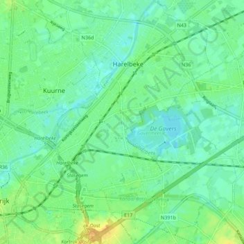
Name: Harelbeke topographic map, elevation, terrain.
Location: Harelbeke, Kortrijk, West-Vlaanderen, Vlaanderen, 8530, België (50.81798 3.28529 50.87142 3.34926)
Average elevation: 52 ft
Minimum elevation: 23 ft
Maximum elevation: 108 ft
Make a donation
Gear up for your next adventure:
As an Amazon Associate, this site earns from qualifying purchases at no extra cost to you.
Other topographic maps
Click on a map to view its topography, its elevation and its terrain.
Stasegem
België > West-Vlaanderen > Kortrijk > Harelbeke
Dit gebeurde eveneens in de nabijheid van de ophaalbrug en was telkens het hoogtepunt van de kermis. Een eend werd losgelaten in het water, de deelnemende zwemmers liepen langs de oever en wachtten tot het dier de oever naderde. Wanneer het voldoende dicht was sprongen één of meerdere zwemmers het water in,…
Average elevation: 59 ft