
Make a donation
Gear up for your next adventure:
As an Amazon Associate, this site earns from qualifying purchases at no extra cost to you.
Pittem topographic map
Click on the map to display elevation.
Make a donation
Gear up for your next adventure:
As an Amazon Associate, this site earns from qualifying purchases at no extra cost to you.
Pittem
Pittem ligt in Zandlemig Vlaanderen, op een uitloper van het Plateau van Tielt. De hoogte varieert van 18 tot 50 meter. De hoogste punten zijn Pittemberg (44 meter) en nabij Zwarte Gat (50 meter). In het zuiden stroomt de Devebeek zuidwaarts.
Make a donation
Gear up for your next adventure:
As an Amazon Associate, this site earns from qualifying purchases at no extra cost to you.
About this map
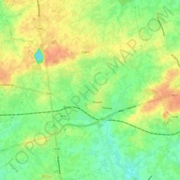
Name: Pittem topographic map, elevation, terrain.
Location: Pittem, Tielt, West-Vlaanderen, 8740, België (50.96446 3.22193 51.03541 3.31209)
Average elevation: 98 ft
Minimum elevation: 36 ft
Maximum elevation: 164 ft
Make a donation
Gear up for your next adventure:
As an Amazon Associate, this site earns from qualifying purchases at no extra cost to you.