
Phetchaburi Province topographic map
Interactive map
Click on the map to display elevation.
About this map
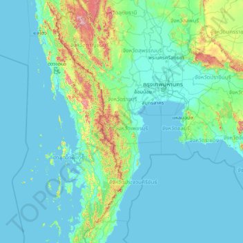
Name: Phetchaburi Province topographic map, elevation, terrain.
Location: Phetchaburi Province, Thailand (10.50929 97.04444 15.62929 102.16444)
Average elevation: 344 ft
Minimum elevation: -7 ft
Maximum elevation: 6,086 ft
Other topographic maps
Click on a map to view its topography, its elevation and its terrain.
Bang Kao
Thailand > Phetchaburi Province
Bang Kao, Phetchaburi Province, Thailand
Average elevation: 49 ft
Cha-am
Thailand > Phetchaburi Province > Cha-am
Cha-am, Phetchaburi Province, Thailand
Average elevation: 36 ft
Kaeng Krachan District
Thailand > Phetchaburi Province
Kaeng Krachan District, Phetchaburi Province, 76170, Thailand
Average elevation: 312 ft