
Thank you for supporting this site ❤️
Make a donation
Make a donation
Gear up for your next adventure:
As an Amazon Associate, this site earns from qualifying purchases at no extra cost to you.
Pūnch District topographic map
Click on the map to display elevation.
Thank you for supporting this site ❤️
Make a donation
Make a donation
Gear up for your next adventure:
As an Amazon Associate, this site earns from qualifying purchases at no extra cost to you.
About this map
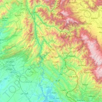
Name: Pūnch District topographic map, elevation, terrain.
Location: Pūnch District, Poonch District, Azad Kashmir, 12200, Pakistan (33.13333 73.05000 34.53333 74.45000)
Average elevation: 4,665 ft
Minimum elevation: 1,079 ft
Maximum elevation: 15,217 ft
Thank you for supporting this site ❤️
Make a donation
Make a donation
Gear up for your next adventure:
As an Amazon Associate, this site earns from qualifying purchases at no extra cost to you.