
Make a donation
Gear up for your next adventure:
As an Amazon Associate, this site earns from qualifying purchases at no extra cost to you.
Doylestown topographic map
Click on the map to display elevation.
Make a donation
Gear up for your next adventure:
As an Amazon Associate, this site earns from qualifying purchases at no extra cost to you.
Doylestown
An electric telegraph station was built in 1846, and the North Pennsylvania Railroad completed a branch to Doylestown in 1856. The first gas lights were introduced in 1854. Because of the town's relatively high elevation and a lack of strong water power, substantial industrial development never occurred and Doylestown evolved to have a professional and residential character.
Make a donation
Gear up for your next adventure:
As an Amazon Associate, this site earns from qualifying purchases at no extra cost to you.
About this map
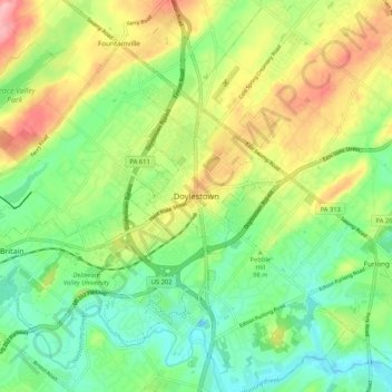
Name: Doylestown topographic map, elevation, terrain.
Location: Doylestown, Bucks County, Pennsylvania, 18901, United States (40.27004 -75.17046 40.35004 -75.09046)
Average elevation: 328 ft
Minimum elevation: 167 ft
Maximum elevation: 574 ft
Bucks County trails, hiking, mountain biking, running and outdoor activities
Make a donation
Gear up for your next adventure:
As an Amazon Associate, this site earns from qualifying purchases at no extra cost to you.