Geolocate

Wacissa topographic map

Click on the map to display elevation.

About this map

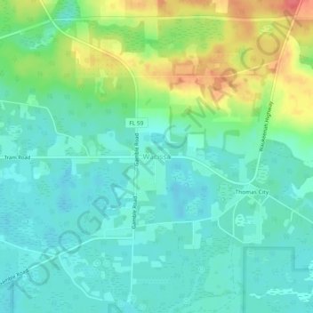
Name: Wacissa topographic map, elevation, terrain.

Location: Wacissa, Jefferson County, Florida, 32361, United States (30.33854 -84.00711 30.37854 -83.96711)

Average elevation: 82 ft

Minimum elevation: 23 ft

Maximum elevation: 223 ft

Jefferson County trails, hiking, mountain biking, running and outdoor activities

Gear up for your next adventure:

🦶Hiking Gaiters - Keep debris and water out of your boots
🧣Hiking Neck Gaiter - Multi‑use neck protection for outdoor weather
🧭Orienteering Set - Complete compass and map reading kit
🪑Ultralight Camp Chairs - Portable seating for resting after a long day of mapping
🏔️Mountain Trail Maps - High‑detail maps for popular peaks

As an Amazon Associate, this site earns from qualifying purchases at no extra cost to you.