
Make a donation
Gear up for your next adventure:
As an Amazon Associate, this site earns from qualifying purchases at no extra cost to you.
Mals topographic map
Click on the map to display elevation.
Make a donation
Gear up for your next adventure:
As an Amazon Associate, this site earns from qualifying purchases at no extra cost to you.
About this map
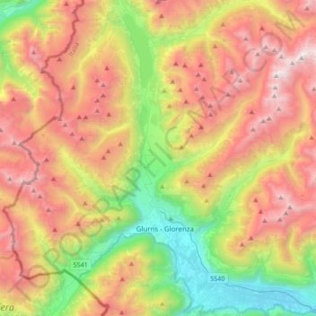
Name: Mals topographic map, elevation, terrain.
Location: Mals, Vinschgau, Bozen, Trentino-Südtirol, 39024, Italien (46.64132 10.40013 46.80439 10.73684)
Average elevation: 6,716 ft
Minimum elevation: 2,818 ft
Maximum elevation: 11,276 ft
Make a donation
Gear up for your next adventure:
As an Amazon Associate, this site earns from qualifying purchases at no extra cost to you.
Other topographic maps
Click on a map to view its topography, its elevation and its terrain.
Schloss Juval
Italien > Trentino-Südtirol > Bozen > Kastelbell-Tschars > Juval
Das Schloss Juval ist eine mittelalterliche Burg mit romanischem Kern im Vinschgau in Südtirol (Italien). Sie befindet sich auf einem Hügel über dem Ausgang des Schnalstals ins Etschtal, auf etwa 1.000 m über Meereshöhe. Die nächstgelegene Ortschaft ist Staben in der Gemeinde Naturns, die Burg steht…
Average elevation: 2,776 ft
Teis
Italien > Trentino-Südtirol > Bozen
Teis (italienisch Tiso) ist eine Fraktion der Gemeinde Villnöß in Südtirol (Italien). Das Dorf liegt am Übergang vom Villnößtal ins Eisacktal auf 963 m Höhe. Zu Teis gehört auch der etwas unterhalb gelegene Weiler Nafen. Der Name des Ortes wird urkundlich erstmals im Jahr 1157 als „Tisis“ erwähnt.…
Average elevation: 2,927 ft
Make a donation
Gear up for your next adventure:
As an Amazon Associate, this site earns from qualifying purchases at no extra cost to you.
Make a donation
Gear up for your next adventure:
As an Amazon Associate, this site earns from qualifying purchases at no extra cost to you.
Vellau
Italien > Trentino-Südtirol > Bozen
Das Dorf liegt hoch über dem Ortszentrum von Algund am südlichen Abhang der Texelgruppe auf etwa 950 m Höhe. Von hier aus hat man einen Ausblick auf Algund, Meran und das Etschtal sowie weit hinauf in den Vinschgau. Überragt wird die Ortschaft von der Mutspitze und der Spronser Rötelspitze.
Average elevation: 3,264 ft
St. Nikolaus
Italien > Trentino-Südtirol > Bozen > Ulten
St. Nikolaus (italienisch San Nicolò) ist eine Fraktion der Gemeinde Ulten in Südtirol (Italien). Das Dorf liegt auf 1256 m Höhe im waldreichen Ultental, das von hohen Bergen umgeben ist.
Average elevation: 5,410 ft
Make a donation
Gear up for your next adventure:
As an Amazon Associate, this site earns from qualifying purchases at no extra cost to you.
Schlossoir
Italien > Trentino-Südtirol > Bozen > Taufers im Münstertal > Schlossoir
Average elevation: 5,069 ft