Geolocate

Czarne topographic map

Click on the map to display elevation.

About this map

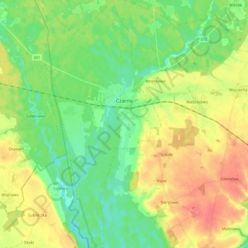
Name: Czarne topographic map, elevation, terrain.

Location: Czarne, gmina Czarne, Człuchów County, Pomeranian Voivodeship, 77-330, Poland (53.60800 16.87363 53.73491 16.97405)

Average elevation: 479 ft

Minimum elevation: 384 ft

Maximum elevation: 620 ft

Other topographic maps

Click on a map to view its topography, its elevation and its terrain.

Suszka

Poland > Pomeranian Voivodeship > Człuchów County

Average elevation: 479 ft

Gear up for your next adventure:

🔦Powerful Headlamps - Ultra-bright hands-free lighting for night navigation
🏥Hiking First Aid Kits - Comprehensive medical kits for remote trail injuries
📷Action Cameras - Rugged cameras to document your journeys across rugged terrain
📶Vehicle Signal Boosters - Improve reception in rural areas while driving to trailheads
📻Weather Alert Radios - Stay informed of storm risks while off-the-grid

As an Amazon Associate, this site earns from qualifying purchases at no extra cost to you.