Geolocate

Ndiowu topographic map

Click on the map to display elevation.

About this map

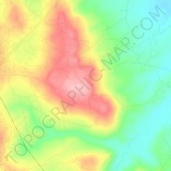
Name: Ndiowu topographic map, elevation, terrain.

Location: Ndiowu, Orumba North, Anambra State, Nigeria (6.03000 7.11333 6.07000 7.15333)

Average elevation: 423 ft

Minimum elevation: 203 ft

Maximum elevation: 669 ft

Gear up for your next adventure:

❄️Traction Cleats - Prevent slips on icy trails during winter hikes
⛑️Personal Locator Beacon - Safety beacon for emergencies
🪶Fire Starter Kit - Reliable fire starter for survival and camping
🎒Day Hiking Backpack - Lightweight backpack perfect for day trips and outdoor adventures
🔌USB Car Charger - Car charger for on‑the‑go power needs

As an Amazon Associate, this site earns from qualifying purchases at no extra cost to you.