
Make a donation
Gear up for your next adventure:
As an Amazon Associate, this site earns from qualifying purchases at no extra cost to you.
Cerro Risco Plateado topographic map
Click on the map to display elevation.
Make a donation
Gear up for your next adventure:
As an Amazon Associate, this site earns from qualifying purchases at no extra cost to you.
Cerro Risco Plateado
Risco Plateado is a stratovolcano in Argentina, with an elevation of 4,999 metres (16,401 ft) above sea level. With a prominence of 1,602 metres (5,256 ft), it is one of the many ultra prominent peaks in the Andes. The equilibrium line altitude of the volcano lies at an altitude of 3,800 metres (12,500 ft).
Make a donation
Gear up for your next adventure:
As an Amazon Associate, this site earns from qualifying purchases at no extra cost to you.
About this map
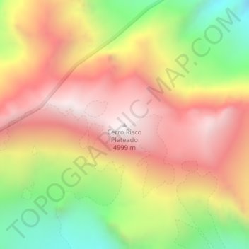
Name: Cerro Risco Plateado topographic map, elevation, terrain.
Average elevation: 14,383 ft
Minimum elevation: 12,165 ft
Maximum elevation: 16,158 ft
Make a donation
Gear up for your next adventure:
As an Amazon Associate, this site earns from qualifying purchases at no extra cost to you.
Other topographic maps
Click on a map to view its topography, its elevation and its terrain.