
Make a donation
Gear up for your next adventure:
As an Amazon Associate, this site earns from qualifying purchases at no extra cost to you.
Friedens topographic map
Click on the map to display elevation.
Make a donation
Gear up for your next adventure:
As an Amazon Associate, this site earns from qualifying purchases at no extra cost to you.
Friedens
Friedens occupies a gently elevated upland setting in Somerset County, within the Laurel Highlands of southwestern Pennsylvania, where the landscape belongs to the broad Appalachian Plateau rather than to a flat lowland plain. The village sits among rounded hills, shallow stream valleys, and open rural slopes, with nearby elevations generally clustered around the low 2,000-foot range, dropping into local drainage corridors near Wells Creek and rising toward higher knobs and ridges around the settlement. Relief is moderate and rolling rather than abrupt: roads and fields follow broad benches and softened hillcrests, while small creeks have carved narrow swales that give the area a subtly dissected texture. In its wider context, Friedens lies in a county known for high plateau country between Laurel Hill and the Allegheny Mountains, with Pennsylvania’s highest elevations nearby, giving the place a distinctly upland Appalachian character marked by cool high ground, agricultural clearings, wooded slopes, and gradual but persistent elevation changes.
Make a donation
Gear up for your next adventure:
As an Amazon Associate, this site earns from qualifying purchases at no extra cost to you.
About this map
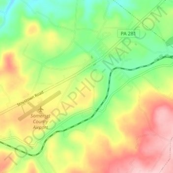
Name: Friedens topographic map, elevation, terrain.
Average elevation: 2,162 ft
Minimum elevation: 1,903 ft
Maximum elevation: 2,464 ft
Somerset County trails, hiking, mountain biking, running and outdoor activities
Make a donation
Gear up for your next adventure:
As an Amazon Associate, this site earns from qualifying purchases at no extra cost to you.