
Make a donation
Gear up for your next adventure:
As an Amazon Associate, this site earns from qualifying purchases at no extra cost to you.
共和县 topographic map
Click on the map to display elevation.
Make a donation
Gear up for your next adventure:
As an Amazon Associate, this site earns from qualifying purchases at no extra cost to you.
共和县
恰卜恰镇,是中华人民共和国青海省海南藏族自治州共和县下辖的一个乡镇级行政单位。也是海南藏族自治州的治所,地处恰卜恰河谷上部沿岸,年平均气温3.4℃,平均年降水量321.4毫米,平均海拔2800米。2010年总人口46,907人。
Make a donation
Gear up for your next adventure:
As an Amazon Associate, this site earns from qualifying purchases at no extra cost to you.
About this map
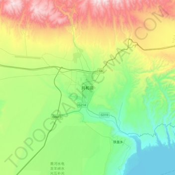
Name: 共和县 topographic map, elevation, terrain.
Location: 共和县, 海南藏族自治州, 青海省, 中国 (36.12150 100.45581 36.44150 100.77581)
Average elevation: 9,961 ft
Minimum elevation: 8,425 ft
Maximum elevation: 13,100 ft
Make a donation
Gear up for your next adventure:
As an Amazon Associate, this site earns from qualifying purchases at no extra cost to you.
Other topographic maps
Click on a map to view its topography, its elevation and its terrain.