
Hansville topographic map
Click on the map to display elevation.
About this map
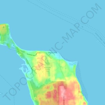
Name: Hansville topographic map, elevation, terrain.
Location: Hansville, Kitsap County, Washington, 98340, United States (47.87870 -122.59431 47.95870 -122.51431)
Average elevation: 46 ft
Minimum elevation: 0 ft
Maximum elevation: 384 ft
Kitsap County trails, hiking, mountain biking, running and outdoor activities
Other topographic maps
Click on a map to view its topography, its elevation and its terrain.
Manitou Beach Park
United States > Washington > Kitsap County > Bainbridge Island
Average elevation: 89 ft
Bainbridge Island
United States > Washington > Kitsap County > Bainbridge Island
Average elevation: 95 ft