
Thank you for supporting this site ❤️
Make a donation
Make a donation
Gear up for your next adventure:
As an Amazon Associate, this site earns from qualifying purchases at no extra cost to you.
Acquaviva topographic map
Click on the map to display elevation.
Thank you for supporting this site ❤️
Make a donation
Make a donation
Gear up for your next adventure:
As an Amazon Associate, this site earns from qualifying purchases at no extra cost to you.
About this map
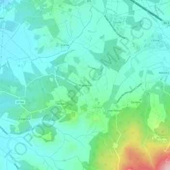
Name: Acquaviva topographic map, elevation, terrain.
Location: Acquaviva, Strove, Monteriggioni, Siena, Toscana, Italia (43.36481 11.14822 43.40481 11.18822)
Average elevation: 787 ft
Minimum elevation: 568 ft
Maximum elevation: 1,614 ft
Thank you for supporting this site ❤️
Make a donation
Make a donation
Gear up for your next adventure:
As an Amazon Associate, this site earns from qualifying purchases at no extra cost to you.