Geolocate

Mardan topographic map

Click on the map to display elevation.

About this map

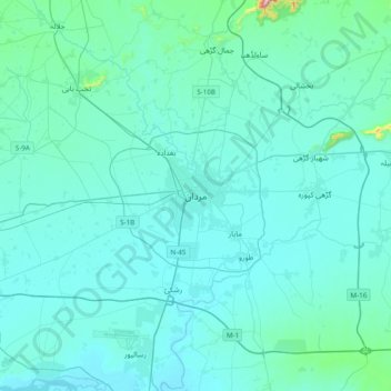
Name: Mardan topographic map, elevation, terrain.

Location: Mardan, Swabi, Khyber Pakhtunkhwa, 23200, Pakistan (34.03380 71.88515 34.35380 72.20515)

Average elevation: 1,076 ft

Minimum elevation: 932 ft

Maximum elevation: 2,933 ft

Gear up for your next adventure:

🧥Waterproof Jacket for Hiking - Breathable and rugged rain jacket for outdoor excursions
🚁Photography Drones - Capture stunning aerial views of landforms and topography
🧷Carabiner Set - Durable clips for gear attachment
🪶Trail Camera - Capture wildlife on your hikes
🔥Camping Stove - Portable stove for camping and backcountry cooking

As an Amazon Associate, this site earns from qualifying purchases at no extra cost to you.