
Thank you for supporting this site ❤️
Make a donation
Make a donation
Gear up for your next adventure:
As an Amazon Associate, this site earns from qualifying purchases at no extra cost to you.
Sertã topographic map
Click on the map to display elevation.
Thank you for supporting this site ❤️
Make a donation
Make a donation
Gear up for your next adventure:
As an Amazon Associate, this site earns from qualifying purchases at no extra cost to you.
About this map
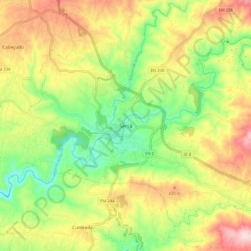
Name: Sertã topographic map, elevation, terrain.
Location: Sertã, Castelo Branco, 6100-732, Portugal (39.76521 -8.13644 39.84521 -8.05644)
Average elevation: 1,089 ft
Minimum elevation: 571 ft
Maximum elevation: 1,716 ft
Thank you for supporting this site ❤️
Make a donation
Make a donation
Gear up for your next adventure:
As an Amazon Associate, this site earns from qualifying purchases at no extra cost to you.