Geolocate

Huntsville topographic map

Click on the map to display elevation.

About this map

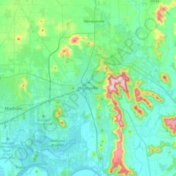
Name: Huntsville topographic map, elevation, terrain.

Location: Huntsville, Madison County, Alabama, 35804, United States (34.56985 -86.74590 34.88985 -86.42590)

Average elevation: 738 ft

Minimum elevation: 548 ft

Maximum elevation: 1,650 ft

Madison County trails, hiking, mountain biking, running and outdoor activities

Gear up for your next adventure:

🦶Carbon Trekking Poles - Reduce knee impact on steep descents with ultra-light poles
🌄Hiking Binoculars - Compact binoculars for scenic views and trail spotting
🧭Pro Hiking Compasses - High-accuracy liquid-filled compasses for topographic orientation
👟Trail Running Shoes - Lightweight shoes for trail runners
🌧️Backpack Rain Cover - Keep gear dry in wet weather

As an Amazon Associate, this site earns from qualifying purchases at no extra cost to you.