
Thank you for supporting this site ❤️
Make a donation
Make a donation
Gear up for your next adventure:
As an Amazon Associate, this site earns from qualifying purchases at no extra cost to you.
Monte Castillo topographic map
Click on the map to display elevation.
Thank you for supporting this site ❤️
Make a donation
Make a donation
Gear up for your next adventure:
As an Amazon Associate, this site earns from qualifying purchases at no extra cost to you.
Monte Castillo
El monte Castillo es un monte ubicado en la sierra del Dobra, dentro del municipio de Puente Viesgo, en Cantabria, (España). Conocido por las cuevas de arte rupestre que alberga. Tiene 355 msnm de altitud.
Thank you for supporting this site ❤️
Make a donation
Make a donation
Gear up for your next adventure:
As an Amazon Associate, this site earns from qualifying purchases at no extra cost to you.
About this map
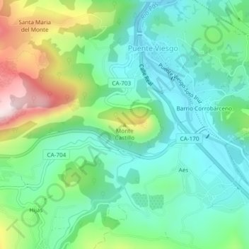
Name: Monte Castillo topographic map, elevation, terrain.
Average elevation: 591 ft
Minimum elevation: 177 ft
Maximum elevation: 1,568 ft
Thank you for supporting this site ❤️
Make a donation
Make a donation
Gear up for your next adventure:
As an Amazon Associate, this site earns from qualifying purchases at no extra cost to you.