Geolocate

Ore City topographic map

Click on the map to display elevation.

About this map

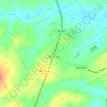
Name: Ore City topographic map, elevation, terrain.

Location: Ore City, Upshur County, Texas, United States (32.78608 -94.73523 32.81585 -94.70216)

Average elevation: 308 ft

Minimum elevation: 233 ft

Maximum elevation: 443 ft

Upshur County trails, hiking, mountain biking, running and outdoor activities

Other topographic maps

Click on a map to view its topography, its elevation and its terrain.

Rhonesboro

United States > Texas > Upshur County

Average elevation: 509 ft

Diana

United States > Texas > Upshur County

Average elevation: 312 ft

Pattonfield

United States > Texas > Upshur County

Average elevation: 397 ft

Gear up for your next adventure:

🛰️Satellite Messengers - Emergency SOS and two-way messaging for off-grid adventures
🏕️Family Camping Gear - Essentials for group camping trips
🧭Pro Hiking Compasses - High-accuracy liquid-filled compasses for topographic orientation
🩳Quick‑Dry Hiking Shorts - Comfortable and quick‑dry shorts for summer hiking
🔥Camping Stove - Portable stove for camping and backcountry cooking

As an Amazon Associate, this site earns from qualifying purchases at no extra cost to you.