
Make a donation
Gear up for your next adventure:
As an Amazon Associate, this site earns from qualifying purchases at no extra cost to you.
Afton topographic map
Click on the map to display elevation.
Make a donation
Gear up for your next adventure:
As an Amazon Associate, this site earns from qualifying purchases at no extra cost to you.
About this map
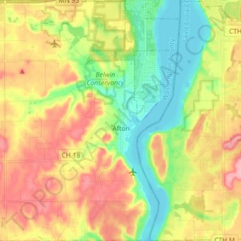
Name: Afton topographic map, elevation, terrain.
Location: Afton, Washington County, Minnesota, 55001, United States (44.86186 -92.86268 44.94915 -92.75655)
Average elevation: 850 ft
Minimum elevation: 666 ft
Maximum elevation: 1,070 ft
Washington County trails, hiking, mountain biking, running and outdoor activities
Make a donation
Gear up for your next adventure:
As an Amazon Associate, this site earns from qualifying purchases at no extra cost to you.
Other topographic maps
Click on a map to view its topography, its elevation and its terrain.
St. Croix River Boom Site Landing
United States > Minnesota > Washington County > Stillwater Township
Average elevation: 830 ft
Grey Cloud Island
United States > Minnesota > Washington County > Grey Cloud Island Township
Average elevation: 738 ft
Twin Pine Mobile Home Park
United States > Minnesota > Washington County > Hugo
Average elevation: 925 ft