Geolocate

West Devon topographic map

Click on the map to display elevation.

About this map

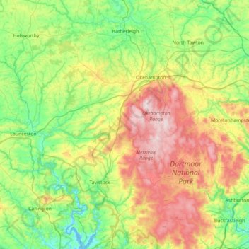
Name: West Devon topographic map, elevation, terrain.

Location: West Devon, Devon, South West England, England, United Kingdom (50.42937 -4.33510 50.87462 -3.73227)

Average elevation: 656 ft

Minimum elevation: -3 ft

Maximum elevation: 2,008 ft

Gear up for your next adventure:

👟Trail Running Shoes - Lightweight shoes for trail runners
🗺️NatGeo Topo Maps - High-quality waterproof printed topographic maps of US Parks
🎒Trail Energy Bars - High‑calorie bars for hiking energy
🎒Trekking Poles - Sturdy poles for balance and stability on rough terrain
🏕️Family Camping Gear - Essentials for group camping trips

As an Amazon Associate, this site earns from qualifying purchases at no extra cost to you.