
Lepreau topographic map
Interactive map
Click on the map to display elevation.
About this map
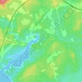
Name: Lepreau topographic map, elevation, terrain.
Average elevation: 108 ft
Minimum elevation: -20 ft
Maximum elevation: 315 ft
Other topographic maps
Click on a map to view its topography, its elevation and its terrain.
Haggertys Cove
Canada > New Brunswick > Lepreau Parish
Haggertys Cove, Lepreau Parish, Charlotte County, New Brunswick, Canada
Average elevation: 43 ft
Squaw Mountain
Canada > New Brunswick > Lepreau Parish
Squaw Mountain, Lepreau Parish, Charlotte County, New Brunswick, Canada
Average elevation: 397 ft
Eagle Mountain
Canada > New Brunswick > Lepreau Parish
Eagle Mountain, Lepreau Parish, Charlotte County, New Brunswick, Canada
Average elevation: 466 ft