
Make a donation
Gear up for your next adventure:
As an Amazon Associate, this site earns from qualifying purchases at no extra cost to you.
Baiselsberg topographic map
Click on the map to display elevation.
Make a donation
Gear up for your next adventure:
As an Amazon Associate, this site earns from qualifying purchases at no extra cost to you.
About this map
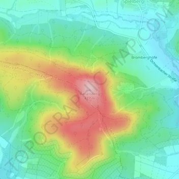
Name: Baiselsberg topographic map, elevation, terrain.
Average elevation: 1,047 ft
Minimum elevation: 781 ft
Maximum elevation: 1,558 ft
Make a donation
Gear up for your next adventure:
As an Amazon Associate, this site earns from qualifying purchases at no extra cost to you.
Other topographic maps
Click on a map to view its topography, its elevation and its terrain.
Spielberg
Deutschland > Baden-Württemberg > Landkreis Ludwigsburg > Sachsenheim
Average elevation: 1,040 ft
Häfnerhaslach
Deutschland > Baden-Württemberg > Landkreis Ludwigsburg > Sachsenheim
Average elevation: 1,102 ft
Hohenhaslach
Deutschland > Baden-Württemberg > Landkreis Ludwigsburg > Sachsenheim
Average elevation: 935 ft