
Make a donation
Gear up for your next adventure:
As an Amazon Associate, this site earns from qualifying purchases at no extra cost to you.
Letzau topographic map
Click on the map to display elevation.
Make a donation
Gear up for your next adventure:
As an Amazon Associate, this site earns from qualifying purchases at no extra cost to you.
Letzau
Im 9. und 10. Jahrhundert entstanden die sogenannten Königstraßen oder Hochstraßen, die abseits der Flüsse über die Höhenzüge führten. Zu diesen gehörte die Letzauer Hochstraße, die von Anton Dollacker und Michel Hardt beschrieben wird. Sie führte von Amberg über Schnaittenbach, Luhe, Letzau, Floß und Plößberg nach Tirschenreuth.
Make a donation
Gear up for your next adventure:
As an Amazon Associate, this site earns from qualifying purchases at no extra cost to you.
About this map
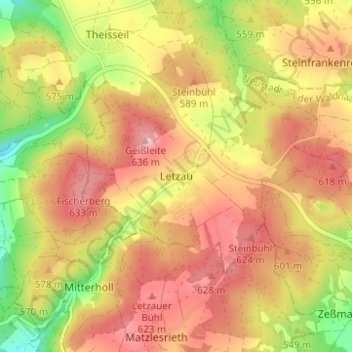
Name: Letzau topographic map, elevation, terrain.
Average elevation: 1,867 ft
Minimum elevation: 1,496 ft
Maximum elevation: 2,139 ft
Make a donation
Gear up for your next adventure:
As an Amazon Associate, this site earns from qualifying purchases at no extra cost to you.
Other topographic maps
Click on a map to view its topography, its elevation and its terrain.
Grafenwöhr
Deutschland > Bayern > Landkreis Neustadt an der Waldnaab
Der größte Teil des Truppenübungsplatzes gehört heute zum Stadtgebiet. Das ehemals gemeindefreie Gebiet Truppenübungsplatz Grafenwöhr mit einer Fläche von 8749,97 Hektar, das die 1938/39 aufgelösten Gemeinden Haag, Höhenberg, Hopfenohe, Kaundorf, Leuzenhof, Nunkas, Oberfrankenohe und Pappenberg…
Average elevation: 1,476 ft
Neustadt an der Waldnaab
Deutschland > Bayern > Landkreis Neustadt an der Waldnaab
Average elevation: 1,460 ft
Waidhaus
Deutschland > Bayern > Landkreis Neustadt an der Waldnaab
Waidhaus liegt in der Planungsregion Oberpfalz-Nord an der Grenze zu Tschechien. Waidhaus liegt am Fuße des Sulzbergs, über dessen Gipfel, dem Alten Schloß sich bis auf 755 Meter Höhe ein Naturwaldreservat mit urwaldähnlichem Laub- und Mischwald ausdehnt. Seit Jahrhunderten führte die Handelsstraße von…
Average elevation: 1,831 ft
Stockweiher
Deutschland > Bayern > Landkreis Neustadt an der Waldnaab > Kirchenthumbach > Metzenhof
Average elevation: 1,463 ft
Make a donation
Gear up for your next adventure:
As an Amazon Associate, this site earns from qualifying purchases at no extra cost to you.
92697
Deutschland > Bayern > Landkreis Neustadt an der Waldnaab > Georgenberg
Average elevation: 2,110 ft
92676
Deutschland > Bayern > Landkreis Neustadt an der Waldnaab > Speinshart
Average elevation: 1,493 ft
Luhe-Wildenau
Deutschland > Bayern > Landkreis Neustadt an der Waldnaab
Außerdem gibt es noch den Wohnplatz Haselhöhe.
Average elevation: 1,404 ft
92655
Deutschland > Bayern > Landkreis Neustadt an der Waldnaab > Grafenwöhr
Average elevation: 1,512 ft
Make a donation
Gear up for your next adventure:
As an Amazon Associate, this site earns from qualifying purchases at no extra cost to you.
Kirchendemenreuth
Deutschland > Bayern > Landkreis Neustadt an der Waldnaab
Average elevation: 1,677 ft
Make a donation
Gear up for your next adventure:
As an Amazon Associate, this site earns from qualifying purchases at no extra cost to you.
Neustadt am Kulm
Deutschland > Bayern > Landkreis Neustadt an der Waldnaab
Average elevation: 1,545 ft
Altenstadt an der Waldnaab
Deutschland > Bayern > Landkreis Neustadt an der Waldnaab
Average elevation: 1,437 ft
Make a donation
Gear up for your next adventure:
As an Amazon Associate, this site earns from qualifying purchases at no extra cost to you.
Eslarn
Deutschland > Bayern > Landkreis Neustadt an der Waldnaab
In Eslarn wird alle fünf Jahre das Heimatfest gefeiert. 1995 wurde das etwa zehn Tage dauernde Fest zum 20. Mal veranstaltet. Ein Höhepunkt ist der Festumzug mit zahlreichen Vereinen aus Eslarn und Umgebung sowie den Heimatvereinen von Eslarnern in der Fremde.
Average elevation: 1,834 ft
Make a donation
Gear up for your next adventure:
As an Amazon Associate, this site earns from qualifying purchases at no extra cost to you.
92727
Deutschland > Bayern > Landkreis Neustadt an der Waldnaab > Waldthurn
Average elevation: 1,890 ft
92709
Deutschland > Bayern > Landkreis Neustadt an der Waldnaab > Moosbach
Average elevation: 1,893 ft
Windischeschenbach
Deutschland > Bayern > Landkreis Neustadt an der Waldnaab
Average elevation: 1,627 ft
Make a donation
Gear up for your next adventure:
As an Amazon Associate, this site earns from qualifying purchases at no extra cost to you.
Speinsharter Forst
Deutschland > Bayern > Landkreis Neustadt an der Waldnaab
Average elevation: 1,539 ft
Make a donation
Gear up for your next adventure:
As an Amazon Associate, this site earns from qualifying purchases at no extra cost to you.
Vohenstrauß
Deutschland > Bayern > Landkreis Neustadt an der Waldnaab
Altenstadt bei Vohenstrauß | Altentreswitz | Arnmühle | Binnermühle | Böhmischbruck | Braunetsrieth | Erpetshof | Fiedlbühl | Fürstenmühle | Galgenberg | Goldbachschleife | Grünhammer | Hammer | Hartwichshof | Herrnmühle | Iltismühle | Kaimling | Kaltenbaum | Kapplhaus | Kößing | Kößlmühle |…
Average elevation: 1,791 ft
Bechtsrieth
Deutschland > Bayern > Landkreis Neustadt an der Waldnaab
Bechtsrieth wurde im Jahre 1408 als „Perchtersreuth“, im Jahr 1436 als „Perchtolzriet“ urkundlich erwähnt. Die Namensendung -reuth bzw. -riet, die mit dem Wort Rodung zusammenhängt, deutet darauf hin, dass Bechtsrieth im Rahmen des großen Landausbaus vom 11. bis zum beginnenden 13. Jahrhundert am…
Average elevation: 1,670 ft
Eschenbach in der Oberpfalz (VGem)
Deutschland > Bayern > Landkreis Neustadt an der Waldnaab
Average elevation: 1,499 ft
Make a donation
Gear up for your next adventure:
As an Amazon Associate, this site earns from qualifying purchases at no extra cost to you.
Kohlberg
Deutschland > Bayern > Landkreis Neustadt an der Waldnaab
In einschlägiger Fachliteratur wird die geologische Untereinheit, in der Kohlberg liegt, als Kohlberger Höhenrücken bezeichnet.
Average elevation: 1,480 ft
Floß
Deutschland > Bayern > Landkreis Neustadt an der Waldnaab
Die Floß umgebenden Dörfer sind älter als Floß selbst. Zunächst entstanden Siedlungen auf den Höhen, da die Flussniederung sumpfig und von Überschwemmung bedroht war. Floß wurde dann als Handels- und Verwaltungsmittelpunkt an der alten Straßenkreuzung der Straße von Weiden über Floß nach Plößberg…
Average elevation: 1,778 ft
Löhlbach
Deutschland > Bayern > Landkreis Neustadt an der Waldnaab > Vohenstrauß > Untertresenfeld
Average elevation: 1,755 ft
Make a donation
Gear up for your next adventure:
As an Amazon Associate, this site earns from qualifying purchases at no extra cost to you.
Eschenbach i.d.OPf.
Deutschland > Bayern > Landkreis Neustadt an der Waldnaab
Östlich vom Stadtkern am Netzaberg entstand bis 2008 die größte US-Garnison außerhalb des festländischen US-Staatsgebiets, unter dem Namen Netzaberg Housing Area. Insgesamt wurden 830 Doppel- und Dreifachhäuser für US-Soldaten der sogenannten Strykerbrigade (benannt nach den leicht bewaffneten…
Average elevation: 1,450 ft
Make a donation
Gear up for your next adventure:
As an Amazon Associate, this site earns from qualifying purchases at no extra cost to you.
Kohlberg
Deutschland > Bayern > Landkreis Neustadt an der Waldnaab
In einschlägiger Fachliteratur wird die geologische Untereinheit, in der Kohlberg liegt, als Kohlberger Höhenrücken bezeichnet.
Average elevation: 1,480 ft
92676
Deutschland > Bayern > Landkreis Neustadt an der Waldnaab > Tremmersdorf
Average elevation: 1,493 ft
Make a donation
Gear up for your next adventure:
As an Amazon Associate, this site earns from qualifying purchases at no extra cost to you.