
Ceres topographic map
Click on the map to display elevation.
Ceres
Ceres experiences a typical Mediterranean climate tempered by its altitude. The town experiences warmer temperatures in summer, due to its inland location with infrequent rainfall, however winters are cool to quite cold and wet, with frequent snowfalls on the surrounding higher-lying ground, rarely falling on the valley floor itself. Total annual precipitation averages 1088 mm, with average temperatures ranging from a February maximum of 29,9 °C to a July minimum of 2,4 °C.
About this map
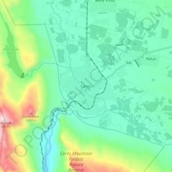
Name: Ceres topographic map, elevation, terrain.
Average elevation: 1,923 ft
Minimum elevation: 1,060 ft
Maximum elevation: 4,491 ft
Other topographic maps
Click on a map to view its topography, its elevation and its terrain.
Witzenberg Ward 9
South Africa > Western Cape > Cape Winelands District Municipality > Witzenberg Local Municipality
Average elevation: 2,927 ft
Tankwa Town
South Africa > Western Cape > Cape Winelands District Municipality > Witzenberg Local Municipality
Average elevation: 1,565 ft
Tankwa Town
South Africa > Western Cape > Cape Winelands District Municipality > Witzenberg Local Municipality
Average elevation: 1,565 ft