Geolocate

Siachen Glacier topographic map

Interactive map

Click on the map to display elevation.

About this map

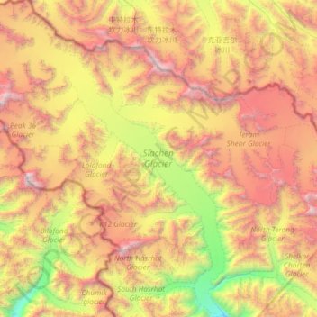
Name: Siachen Glacier topographic map, elevation, terrain.

Location: Siachen Glacier, Nubra, Leh District, Ladakh, India (35.19575 76.75192 35.67020 77.21053)

Average elevation: 17,874 ft

Minimum elevation: 11,699 ft

Maximum elevation: 25,184 ft

Other topographic maps

Click on a map to view its topography, its elevation and its terrain.

Khardung

India > Ladakh > Nubra

Khardung, Nubra, Leh District, Ladakh, India

Average elevation: 13,711 ft

Gapshan

India > Ladakh > Nubra

Gapshan, Nubra, Leh District, Ladakh, India

Average elevation: 15,896 ft

Terche

India > Ladakh > Nubra

Terche, Nubra, Leh district, Ladakh, India

Average elevation: 10,466 ft

Chang La

India > Ladakh > Nubra

Chang La, Nubra, Leh district, Ladakh, India

Average elevation: 17,927 ft