
Thank you for supporting this site ❤️
Make a donation
Make a donation
Gear up for your next adventure:
As an Amazon Associate, this site earns from qualifying purchases at no extra cost to you.
Dantxarinea topographic map
Click on the map to display elevation.
Thank you for supporting this site ❤️
Make a donation
Make a donation
Gear up for your next adventure:
As an Amazon Associate, this site earns from qualifying purchases at no extra cost to you.
About this map
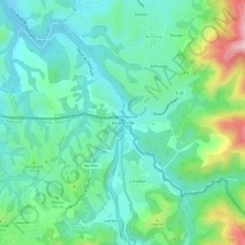
Name: Dantxarinea topographic map, elevation, terrain.
Location: Dantxarinea, Urdazubi/Urdax, Baztan-Bidasoa, 31720, Espagne (43.27263 -1.52574 43.31263 -1.48574)
Average elevation: 459 ft
Minimum elevation: 138 ft
Maximum elevation: 1,407 ft
Thank you for supporting this site ❤️
Make a donation
Make a donation
Gear up for your next adventure:
As an Amazon Associate, this site earns from qualifying purchases at no extra cost to you.